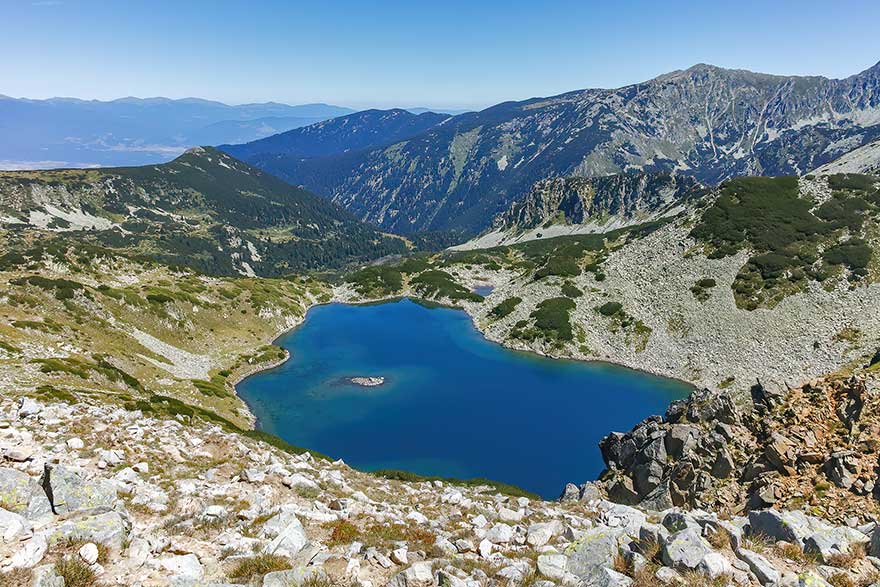

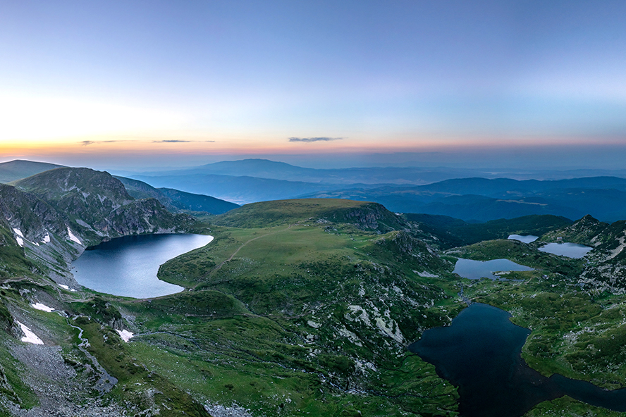
High in northwestern Rila, seven glacial lakes lie one above another like a staircase of blue. Their colours shift from pale turquoise to almost black, framed by granite ridges, alpine grasslands and lingering snowfields.
The Seven Rila Lakes are among Bulgaria’s best-known natural landmarks, but they are more than a viewpoint. They form a connected, fragile ecosystem inside Rila National Park, between 2,095 and 2,535 metres above sea level.
Seven Lakes Carved by Ice
The lakes occupy stepped glacial cirques created during the Pleistocene ice ages. Moving and retreating glaciers carved hollows into the granite and left natural rock and moraine barriers; snowmelt and rainfall later filled the basins.
Small streams and cascades connect the lakes. Water from the Tear, Eye and Kidney reaches the Twin, then continues through the lower system towards the Trefoil, Fish Lake and Lower Lake. The outflow contributes to the Dzherman River.
For a different perspective on the cirque through the year, see this aerial view of the Seven Rila Lakes.
The Seven Rila Lakes: Data
Together, the lakes cover approximately 37.1 hectares and contain about 2.97 million cubic metres of water. The figures below use published morphometric data; small differences appear between surveys because shorelines and water levels change seasonally.
| Lake | Bulgarian name | Elevation | Surface area | Maximum depth | Water volume | Distinguishing feature |
|---|---|---|---|---|---|---|
| The Tear | Сълзата (Salzata) | 2,535 m | 0.7 ha | 4.5 m | 15,000 m³ | Highest, smallest and exceptionally clear |
| The Eye | Окото (Okoto) | 2,440 m | 6.8 ha | 37.5 m | 860,000 m³ | Deepest glacial lake in Bulgaria |
| The Kidney | Бъбрека (Babreka) | 2,282 m | 8.5 ha | 28 m | 1,170,000 m³ | Largest by volume; steep shores |
| The Twin | Близнака (Bliznaka) | 2,243 m | 9.1 ha | 27.5 m | 590,000 m³ | Largest by surface area; narrows into two lobes in dry periods |
| The Trefoil | Трилистника (Trilistnika) | 2,216 m | 2.6 ha | 6.5 m | 54,000 m³ | Irregular, three-lobed outline and low banks |
| Fish Lake | Рибното езеро (Ribnoto ezero) | 2,184 m | 3.5 ha | 2.5 m | 38,000 m³ | Shallowest; beside the old Seven Lakes hut |
| The Lower Lake | Долното езеро (Dolnoto ezero) | 2,095 m | 5.9 ha | 11 m | 240,000 m³ | Lowest lake; gathers much of the system’s outflow |
Source: scientific morphometric and hydro-climatic study of the Seven Rila Lakes. The Eye’s depth is commonly given as 37.5 m and rounded to 38 m in some studies.
What Kind of Water Is in the Lakes?
These are natural freshwater glacial cirque lakes, or tarns, fed mainly by snowmelt, rain and surface runoff. Levels are usually highest during the spring and early-summer thaw, then fall through late summer and autumn.
Ecologically, the system is oligotrophic to mesotrophic: naturally low to moderate in nutrients, cold, clear and well oxygenated. Typical transparency is 10–15 metres, summer water temperature about 10–12°C, dissolved oxygen 10–14 mg/l and pH 6.8–7.2. The lakes freeze in the cold season, with snow or ice sometimes remaining into June.
Their clarity should not be mistaken for bathing water. The lakes are protected habitats, and entering, bathing or swimming in them is prohibited.
Fish, Aquatic Life, Flora and Fauna
Life here must tolerate cold water, a short growing season and months beneath ice. Algae, zooplankton and insect larvae form the base of the food web. Trout occur in parts of the system, but fish are not equally abundant in all seven lakes. “Fish Lake” is a traditional name, not an invitation to cast a line: fishing is prohibited throughout the Seven Rila Lakes area.
Aquatic vegetation is sparse in the coldest, deepest water, but more visible in shallow Fish Lake, where researchers have documented increasing plant growth and eutrophication. Eroded paths carry sediment and nutrients into the water—one reason to remain on the marked trail.
Above the tree line are alpine grasslands, dwarf mountain pine, heath, peat-bog vegetation and rock-adapted plants. Rila National Park protects relict and endemic species including the Rila primrose (Primula deorum). The growing season is short, and picking flowers is forbidden.
The wider park supports Balkan chamois, red foxes, alpine newts, frogs and high-mountain birds; golden eagles may pass overhead. Wildlife is difficult to spot on busy days, so observe quietly from the trail.
A Landscape with Cultural Meaning
The lakes also have spiritual importance. Every August, followers of Peter Deunov gather near the Kidney for Paneurhythmy, a circular outdoor movement ritual. Visitors seeking quiet should choose another date or arrive very early.
Practical Tourist Information
How to Get to the Seven Rila Lakes
The standard approach is not from Rila Monastery. Travel via Sapareva Banya and Panichishte to the lower chairlift station near Pionerska Hut. From Sofia, allow about 1.5–2 hours; summer weekends bring traffic, full car parks and lift queues.
The chairlift takes about 20 minutes to the upper station beside Rilski Ezera Hut at 2,150 m. Hours are seasonal and maintenance closures occur, so check the current chairlift hours and prices. The published 2026 adult fare is €11 one way or €16 return; carry cash in case card service fails.
If the lift is closed, a marked ascent from the lower station adds roughly 1.5–2 hours and about 515 m of elevation gain before the lake circuit even begins.
Route, Time and Difficulty
From the upper station, the classic circuit is approximately 8–10 km and takes 4–5 hours, excluding rests and lift queues. It is a moderate high-mountain hike; the climb beyond the Kidney towards the Eye and Tear is steeper and more exposed.
A shorter outing can turn at the Kidney or Twin. Start early and set a firm turnaround time based on the last descending lift.
The Rila Monastery lies on another side of the massif. Combine it with the lakes by road; the mountain traverse is a demanding full-day route for experienced hikers, not the normal tourist approach.
Best Time to Visit and What to Carry
The most reliable hiking period is late June to early October, particularly July–September. Outside that window conditions can be wintry; even in August, fog, wind, hail and thunderstorms develop quickly.
Carry grippy hiking shoes, waterproof and warm layers, sun protection, food, at least 1.5 litres of water, a charged phone and an offline map. Check the mountain forecast. In an emergency call 112; Mountain Rescue also lists 1470 and +359 2 963 2000.
Rules That Protect the Lakes
The official Rila National Park rules apply throughout the visit:
- Do not enter, bathe or swim in any lake or river.
- Do not fish in the Seven Rila Lakes area; elsewhere in the park, fishing is permitted only at explicitly marked sites.
- Stay on marked paths. Shortcuts damage vegetation, widen erosion scars and carry sediment into the lakes.
- Do not pick flowers, remove plants, collect minerals or damage rock formations.
- Take all rubbish with you and never wash food, dishes or equipment in the lakes.
- Camp and light fires only at designated sites.
- Keep dogs on a lead.
- Do not drive or park outside authorised routes and areas.
- Observe wildlife quietly and never feed fish or other animals.